Gallery
 PM Modi visit USA
 Only the mirror in my washroom and phone gallery see the crazy me : Sara Khan
 Karnataka rain fury: Photos of flooded streets, uprooted trees
 Cannes 2022: Deepika Padukone stuns at the French Riviera in Sabyasachi outfit
 Ranbir Kapoor And Alia Bhatt's Wedding Pics - Sealed With A Kiss
 Oscars 2022: Every Academy Award Winner
 Shane Warne (1969-2022): Australian cricket legend's life in pictures
 Photos: What Russia's invasion of Ukraine looks like on the ground
 Lata Mangeshkar (1929-2022): A pictorial tribute to the 'Nightingale of India'
 PM Modi unveils 216-feet tall Statue of Equality in Hyderabad (PHOTOS)
India Open Competition in Shotgun, organised by the National Rifle Association of India (N
- Hockey India names Amir Ali-led 20-man team for Junior Asia Cup
- Harmanpreet Singh named FIH Player of the Year, PR Sreejesh gets best goalkeeper award
- World Boxing medallist Gaurav Bidhuri to flag off 'Delhi Against Drugs' movement on Nov 17
- U23 World Wrestling Championship: Chirag Chikkara wins gold as India end campaign with nine medals
- FIFA president Infantino confirms at least 9 African teams for the 2026 World Cup
Cyclone Amphan: Landfall begins, to continue for 4 hours Last Updated : 20 May 2020 04:58:16 PM IST 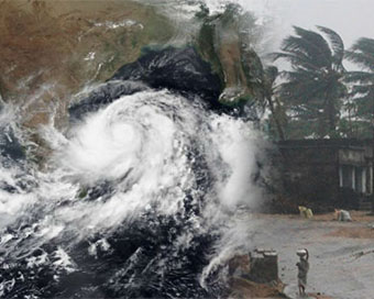
Cyclone Amphan The landfall process of cyclone 'Amphan' commenced at 2.30 p.m. and will continue for four hours, the India Meteorological Department (IMD) said on Wednesday afternoon.
As per 3 p.m. update by the weather agency, "Landfall process commenced since 2.30 p.m. The forward sectors of the wall cloud region are entering into land in West Bengal and the landfall process will continue for four hours."The Cyclone is 190 km east-northeast of Odisha's Paradip, 65 km east-southeast of West Bengal's Digha, 35 km from Sagar island and 225 km south-southwest of Khepupara in Bangladesh.Amphan will move north-northeastwards and cross West Bengal-Bangladesh coast between Digha and Hatiya Islands close to Sundarbans around Sagar Island. During landfall, the intensity of cyclone is likely to be 155 to 165 kmph gusting to 185 kmph.Storm surge during the landfall in West Bengal is expected to be four to six meters above astronomical tide. The surge is expected to inundate low lying areas of South and North 24 Parganas and parts of East Medinipur district.The wind speed in Kolkata, Hooghly and Howrah is likely to range between 110 kmph to 120 kmph gusting to 130 kmph, which may cause extensive damage in the urban areas also.In coastal Odisha, gale wind of 100 to 100 kmph gusting to 125 kmph will also impact Jagatsinghpur, Kendrapara, Bhadrak and Balasore.The weather condition would result in uprooting of trees, communications and power transmission poles, bending of telephone lines and extensive damage to the 'kutcha' and even 'pucca' houses and crops and plantations.The NDRF has positioned over 41 teams to carry out evacuation and relief, Director General S.N. Pradhan had said on Tuesday.IANS New Delhi For Latest Updates Please-
Join us on
Follow us on


172.31.16.186

